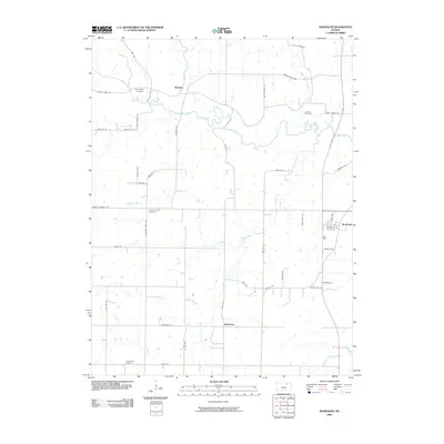
2009 Map of Randolph
USGS Topo · Published 2009About this map
Fancy Creek winds through this rural Riley County landscape, defining the character of the small settlements of Randolph, Walsburg, and Winkler. The map documents a predominantly agricultural area structured by a strict section-line road grid, including family-named routes like Senn Rd and Roblyer Rd. For local historians and genealogists, the distribution of burial grounds such as Saint Johns Cemetery, Catholic Cemetery, and Crooked Creek Cemetery provides a clear view of early community clusters and religious heritage in the northern Kansas plains. Significant landmarks such as Whitson Spr and the crossing of Winkler Mills Rd at North Otter Creek highlight the intersection of natural water sources and early infrastructure. Modern transportation is represented by the north-south corridor of Tuttle Creek Blvd, which connects the region to the larger surrounding area.
Find a feature on this map
46 named features on this map. Tap any name to fly to it.
Don’t see what you’re looking for? This feature index may not catch every label — zoom into the map to look around manually.
Map Details
Editions of this 2009 Randolph Map
This is the sole edition of this map. No revisions or reprints were ever made.
Other maps of this area

1886 · Junction City
USGS Topo · 1:125,000

1889 · Marysville
USGS Topo · 1:125,000

1889 · Junction City
USGS Topo · 1:125,000

1894 · Junction City
USGS Topo · 1:125,000

1894 · Marysville
USGS Topo · 1:125,000

1955 · Manhattan
USGS Topo · 1:250,000

1956 · Manhattan
USGS Topo · 1:250,000

1957 · Manhattan
USGS Topo · 1:250,000
1963 · Bala
USGS Topo · 1:24,000
1963 · Lasita
USGS Topo · 1:24,000