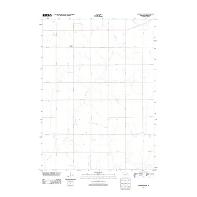
2011 Map of Randolph SW
USGS Topo · Published 2011About this map
Rose Hill Cemetery stands as a quiet landmark amidst the agricultural grid of northern Nebraska in this 2011 survey. The landscape is defined by the meandering courses of Yankton Slough and Middle Logan Creek, which cut through the strictly organized section lines of the rural township. This intersection of natural drainage and human engineering is visible in the network of county roads, such as 864th Rd and 552nd Ave, that provide access to the sprawling farmsteads. The presence of State Hwy Spur 70A indicates a vital corridor for local transit, connecting these remote agricultural sections to the wider region. For those tracing family ties to Pierce County, the map provides a clear view of the land divisions and water sources that have shaped the community's development over generations.
Find a feature on this map
20 named features on this map. Tap any name to fly to it.
Don’t see what you’re looking for? This feature index may not catch every label — zoom into the map to look around manually.
Map Details
Editions of this 2011 Randolph SW Map
This is the sole edition of this map. No revisions or reprints were ever made.
Other maps of this area

1955 · Sioux City
USGS Topo · 1:250,000

1958 · Sioux City
USGS Topo · 1:250,000

1959 · Sioux City
USGS Topo · 1:250,000

1963 · Osmond
USGS Topo · 1:24,000

1963 · Wee Town
USGS Topo · 1:24,000
1963 · Pierce
USGS Topo · 1:24,000

1963 · Norfolk NE
USGS Topo · 1:24,000

1971 · Wausa
USGS Topo · 1:24,000

1971 · Randolph South
USGS Topo · 1:24,000

1971 · Randolph North
USGS Topo · 1:24,000