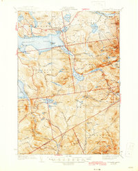
1939 Map of Rangeley
USGS Topo · Published 1944About this map
Rangeley Lake serves as the focal point of this 1930s survey, surrounded by a complex network of high peaks and scattered mountain settlements. The village of Rangeley is established at the lake's northern edge, supported by an Airport and the localized hubs of Mingo Springs and Bemis. This era shows a landscape in transition, where old logging infrastructure is marked Abandoned while recreational and conservation paths like the Appalachian Trail and the Bemis Trail begin to define the high country.
Find a feature on this map
102 named features on this map. Tap any name to fly to it.
Don’t see what you’re looking for? This feature index may not catch every label — zoom into the map to look around manually.
Map Details
Editions of this 1939 Rangeley Map
5 editions found

Other maps of this area

1926 · Dixfield
USGS Topo · 1:62,500

1927 · Rumford
USGS Topo · 1:48,000

1928 · Stratton
USGS Topo · 1:48,000

1929 · Phillips
USGS Topo · 1:48,000

1929 · Dixfield
USGS Topo · 1:62,500

1930 · Rumford
USGS Topo · 1:62,500

1931 · Cupsuptic
USGS Topo · 1:48,000

1932 · Phillips
USGS Topo · 1:62,500

1932 · Stratton
USGS Topo · 1:62,500

1932 · Kennebago Lake
USGS Topo · 1:48,000
Featured Places
- Rangeley, ME
- Dallas Plantation, ME
- Rangeley Plantation, ME
- Madrid Township, ME
- Sandy River Plantation, ME