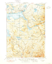
1939 Map of Rangeley
USGS Topo · Published 1950About this map
Rangeley Lake dominates this landscape, its expansive waters surrounded by the high peaks of the Maine woods during the late 1940s. The settlement of Rangeley serves as the primary hub at the lake's head, where an Airport and local roads connect the community to nearby Dallas. This era shows a well-established recreational and seasonal economy, evidenced by the Appalachian Trail winding through the southern mountains past Bemis Mtn and Four Ponds Mtn.
Find a feature on this map
102 named features on this map. Tap any name to fly to it.
Don’t see what you’re looking for? This feature index may not catch every label — zoom into the map to look around manually.
Map Details
Editions of this 1939 Rangeley Map
5 editions found

Other maps of this area

1926 · Dixfield
USGS Topo · 1:62,500

1927 · Rumford
USGS Topo · 1:48,000

1928 · Stratton
USGS Topo · 1:48,000

1929 · Phillips
USGS Topo · 1:48,000

1929 · Dixfield
USGS Topo · 1:62,500

1930 · Rumford
USGS Topo · 1:62,500

1931 · Cupsuptic
USGS Topo · 1:48,000

1932 · Phillips
USGS Topo · 1:62,500

1932 · Stratton
USGS Topo · 1:62,500

1932 · Kennebago Lake
USGS Topo · 1:48,000
Featured Places
- Rangeley, ME
- Dallas Plantation, ME
- Rangeley Plantation, ME
- Madrid Township, ME
- Sandy River Plantation, ME