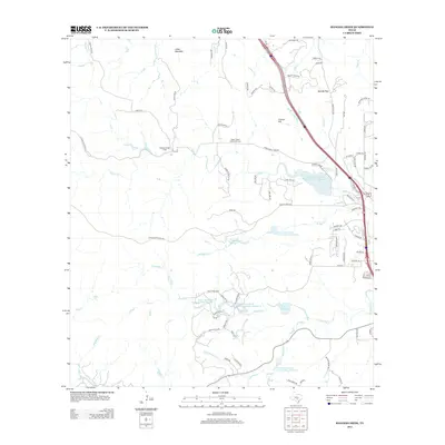
2013 Map of Ranger Creek
USGS Topo · Published 2013About this map
Cibolo Cr and Ranger Cr carve through the Hill Country landscape of Kendall County, defining a region where water management and ranching tradition meet modern development. The presence of multiple water retention projects, such as the Soil Conservation Service Site 1 Reservoir and Soil Conservation Service Site 4 Reservoir, illustrates the critical role of hydraulic engineering in this semi-arid terrain. Local heritage is anchored by the Upper Cibolo Community Cem and the prominent heights of Cannon Hill and Cedar Mountain. The map details a transition from traditional rural routes like Seven Eleven Ranch Rd to the expanding residential infrastructure around the Smith Investment Company Lake Number 1 and Musters Lake. This 2013 survey provides a clear view of the area's geography just north of Boerne before further suburban expansion changed the character of these ranch lands.
Find a feature on this map
90 named features on this map. Tap any name to fly to it.
Don’t see what you’re looking for? This feature index may not catch every label — zoom into the map to look around manually.
Map Details
Editions of this 2013 Ranger Creek Map
This is the sole edition of this map. No revisions or reprints were ever made.
Other maps of this area

1953 · Van Raub
USGS Topo · 1:24,000

1954 · San Antonio
USGS Topo · 1:250,000

1956 · Comfort
USGS Topo · 1:62,500

1956 · Medina Lake
USGS Topo · 1:62,500

1957 · Boerne
USGS Topo · 1:62,500

1957 · San Antonio
USGS Topo · 1:250,000

1964 · Comfort
USGS Topo · 1:24,000

1964 · Waring
USGS Topo · 1:24,000
1964 · Sisterdale
USGS Topo · 1:24,000

1964 · Boerne
USGS Topo · 1:24,000