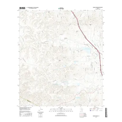
2016 Map of Ranger Creek
USGS Topo · Published 2016About this map
Cibolo Cr and its numerous tributaries carve through this portion of the Texas Hill Country near the Kendall and Bandera county line. The landscape is defined by its complex hydrography, featuring a series of managed water bodies including the Soil Conservation Service Site 1 Reservoir and Smith Investment Company Lake Number 3. These water management features, along with Masters Lake and Lake Oz, illustrate the modern adaptation of the terrain for residential and agricultural stability.
Find a feature on this map
77 named features on this map. Tap any name to fly to it.
Don’t see what you’re looking for? This feature index may not catch every label — zoom into the map to look around manually.
Map Details
Editions of this 2016 Ranger Creek Map
This is the sole edition of this map. No revisions or reprints were ever made.
Other maps of this area

1953 · Van Raub
USGS Topo · 1:24,000

1954 · San Antonio
USGS Topo · 1:250,000

1956 · Comfort
USGS Topo · 1:62,500

1956 · Medina Lake
USGS Topo · 1:62,500

1957 · Boerne
USGS Topo · 1:62,500

1957 · San Antonio
USGS Topo · 1:250,000

1964 · Comfort
USGS Topo · 1:24,000

1964 · Waring
USGS Topo · 1:24,000
1964 · Sisterdale
USGS Topo · 1:24,000

1964 · Boerne
USGS Topo · 1:24,000