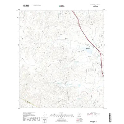
2019 Map of Ranger Creek
USGS Topo · Published 2019About this map
Cibolo Cr and its many tributaries carve through the Hill Country northwest of Boerne, defining a landscape of high ridges and managed water. The 2019 survey shows a modern suburban expansion characterized by complex residential road networks like Lerin Hills Blvd and Blue Heron Blvd interspersed with legacy landmarks. Resting near Cedar Mtn, the Upper Cibolo Community Cem remains a significant point of local heritage amidst the newer developments.
Find a feature on this map
86 named features on this map. Tap any name to fly to it.
Don’t see what you’re looking for? This feature index may not catch every label — zoom into the map to look around manually.
Map Details
Editions of this 2019 Ranger Creek Map
This is the sole edition of this map. No revisions or reprints were ever made.
Other maps of this area

1953 · Van Raub
USGS Topo · 1:24,000

1954 · San Antonio
USGS Topo · 1:250,000

1956 · Comfort
USGS Topo · 1:62,500

1956 · Medina Lake
USGS Topo · 1:62,500

1957 · Boerne
USGS Topo · 1:62,500

1957 · San Antonio
USGS Topo · 1:250,000

1964 · Comfort
USGS Topo · 1:24,000

1964 · Waring
USGS Topo · 1:24,000
1964 · Sisterdale
USGS Topo · 1:24,000

1964 · Boerne
USGS Topo · 1:24,000