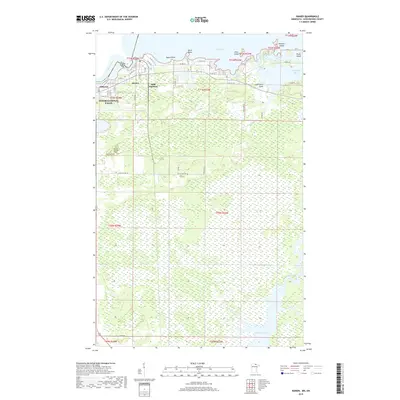
2019 Map of Ranier
USGS Topo · Published 2019About this map
Ranier sits at the critical junction where the Rainy River flows out of Rainy Lake, marking a prominent point on the international border. This northern Minnesota landscape is defined by its complex shoreline, featuring Ogard Point, Birch Point, and numerous islands such as Enos Island and Roberts Island. The transition from the developed outskirts of International Falls to the sprawling wetlands of the south is evident, where the Rat Root River winds its way toward Rat Root Lake. Transportation corridors like Co Hwy 20 and the rail infrastructure at Falls Junction support the local economy, connecting smaller settlements like Jameson to the regional hub. The map captures the intricate balance between the industrial and residential centers of the north and the expansive, water-dominated wilderness that stretches across the southern townships.
Find a feature on this map
51 named features on this map. Tap any name to fly to it.
Don’t see what you’re looking for? This feature index may not catch every label — zoom into the map to look around manually.
Map Details
Editions of this 2019 Ranier Map
This is the sole edition of this map. No revisions or reprints were ever made.
Other maps of this area

1919 · International Falls
USGS Topo · 1:62,500

1954 · International Falls
USGS Topo · 1:250,000

1957 · International Falls
USGS Topo · 1:250,000

1958 · International Falls
USGS Topo · 1:250,000

1963 · Ranier
USGS Topo · 1:24,000

1969 · Island View
USGS Topo · 1:24,000

1969 · Ericsburg NW
USGS Topo · 1:24,000

1969 · Ericsburg
USGS Topo · 1:24,000

1969 · Ray
USGS Topo · 1:24,000

1969 · Ranier
USGS Topo · 1:24,000