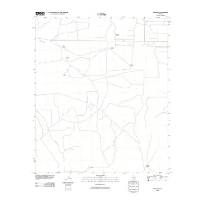
2010 Map of Rankin NE
USGS Topo · Published 2010About this map
Flat Rock Ranch and the surrounding rangeland of Upton County characterize this 2010 survey of the West Texas landscape. The region's economy and infrastructure are clearly defined by the Flat Rock Oil Field in the north and a network of named water-pumping landmarks scattered across the terrain, including the Railroad Windmill, Wineglass Windmill, and Nine-K Windmill. These features indicate the vital role of groundwater management for both livestock and industrial operations in this arid environment.
Find a feature on this map
13 named features on this map. Tap any name to fly to it.
Don’t see what you’re looking for? This feature index may not catch every label — zoom into the map to look around manually.
Map Details
Editions of this 2010 Rankin NE Map
This is the sole edition of this map. No revisions or reprints were ever made.
Other maps of this area

1928 · Rankin
USGS Topo · 1:125,000

1954 · San Angelo
USGS Topo · 1:250,000

1958 · San Angelo
USGS Topo · 1:250,000

1965 · San Angelo
USGS Topo · 1:250,000

1970 · Sevenmile Corner SE
USGS Topo · 1:24,000
1970 · Rankin SE
USGS Topo · 1:24,000
1970 · Cedar Canyon
USGS Topo · 1:24,000

1970 · Sevenmile Corner
USGS Topo · 1:24,000
1970 · Rankin NE
USGS Topo · 1:24,000

1970 · Garrison Draw
USGS Topo · 1:24,000