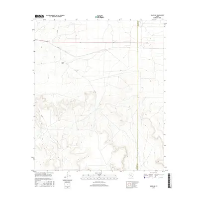
2016 Map of Rankin NE
USGS Topo · Published 2016About this map
Rankin Draw carves a path through the arid landscape of West Texas, serving as a primary drainage feature in this corner of the Permian Basin. This 2016 survey documents the sparse but vital infrastructure of the Edwards Plateau, where the boundary between Upton Co and Reagan Co bisects the high ground. The map illustrates a grid of rural transportation, including Co Rd 230, Co Rd 225, and Co Rd 220, which facilitate movement across the plateau. The terrain is defined by dramatic contour changes as the land drops from the mesas into the draws, reflecting the geologic character of the region. These roads and seasonal watercourses are the primary landmarks for those navigating the open range and energy fields of this expansive territory.
Find a feature on this map
5 named features on this map. Tap any name to fly to it.
Don’t see what you’re looking for? This feature index may not catch every label — zoom into the map to look around manually.
Map Details
Editions of this 2016 Rankin NE Map
This is the sole edition of this map. No revisions or reprints were ever made.
Other maps of this area

1928 · Rankin
USGS Topo · 1:125,000

1954 · San Angelo
USGS Topo · 1:250,000

1958 · San Angelo
USGS Topo · 1:250,000

1965 · San Angelo
USGS Topo · 1:250,000

1970 · Sevenmile Corner SE
USGS Topo · 1:24,000
1970 · Rankin SE
USGS Topo · 1:24,000
1970 · Cedar Canyon
USGS Topo · 1:24,000

1970 · Sevenmile Corner
USGS Topo · 1:24,000
1970 · Rankin NE
USGS Topo · 1:24,000

1970 · Garrison Draw
USGS Topo · 1:24,000