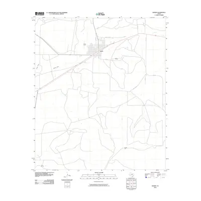
2010 Map of Rankin
USGS Topo · Published 2010About this map
The town of Rankin sits at a crossroads of West Texas history, defined by a grid of streets like Upton St and Railroad Ave that speak to its origins as a transportation hub. Located in Upton County, the landscape is shaped by the ephemeral paths of China Draw and Rankin Draw, which cut through the arid terrain. The settlement’s infrastructure is clearly visible, including the Rankin Airport and the Rankin Cemetery located just east of the main town site.
Find a feature on this map
15 named features on this map. Tap any name to fly to it.
Don’t see what you’re looking for? This feature index may not catch every label — zoom into the map to look around manually.
Map Details
Editions of this 2010 Rankin Map
This is the sole edition of this map. No revisions or reprints were ever made.
Other maps of this area

1928 · Crane
USGS Topo · 1:125,000

1928 · Rankin
USGS Topo · 1:125,000

1954 · Pecos
USGS Topo · 1:250,000

1954 · San Angelo
USGS Topo · 1:250,000

1957 · Pecos
USGS Topo · 1:250,000

1958 · San Angelo
USGS Topo · 1:250,000

1965 · San Angelo
USGS Topo · 1:250,000

1970 · Sevenmile Corner SE
USGS Topo · 1:24,000
1970 · Rankin SE
USGS Topo · 1:24,000
1970 · Cedar Canyon
USGS Topo · 1:24,000