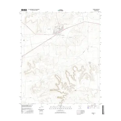
2016 Map of Rankin
USGS Topo · Published 2016About this map
Rankin serves as the primary hub of this West Texas landscape, showing a dense grid of residential streets including Main St, Broadway St, and Grand St. The town's connection to regional transportation is evidenced by the presence of Rankin Airport and the prominent route of Railroad Ave that cuts diagonally through the territory. The surrounding geography is defined by a series of dry watercourses and high points typical of the region, notably Noelke Hill to the south. Several natural drainages, such as China Draw, Rankin Draw, and Appaloosa Run, carve through the terrain, illustrating the drainage patterns that dominate this arid environment. To the east of the town center, Rankin Cem provides a specific point of interest for genealogists and local historians tracking the area's development.
Find a feature on this map
39 named features on this map. Tap any name to fly to it.
Don’t see what you’re looking for? This feature index may not catch every label — zoom into the map to look around manually.
Map Details
Editions of this 2016 Rankin Map
This is the sole edition of this map. No revisions or reprints were ever made.
Other maps of this area

1928 · Crane
USGS Topo · 1:125,000

1928 · Rankin
USGS Topo · 1:125,000

1954 · Pecos
USGS Topo · 1:250,000

1954 · San Angelo
USGS Topo · 1:250,000

1957 · Pecos
USGS Topo · 1:250,000

1958 · San Angelo
USGS Topo · 1:250,000

1965 · San Angelo
USGS Topo · 1:250,000

1970 · Sevenmile Corner SE
USGS Topo · 1:24,000
1970 · Rankin SE
USGS Topo · 1:24,000
1970 · Cedar Canyon
USGS Topo · 1:24,000