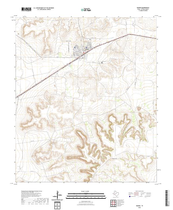
2022 Map of Rankin
USGS Topo · Published 2022About this map
Rankin serves as the focal point of this Upton County survey, situated at the intersection of several regional routes and local avenues. The town's grid is anchored by the Upton County Courthouse, with residential and commercial life organized along streets such as Main St and 12th Ave. On the outskirts of the settlement, the Rankin Airport and the Rankin Cem mark the transition from the town proper to the broader West Texas landscape. The surrounding terrain is defined by dramatic elevation changes, most notably at Noelke Hill to the south. Seasonal drainage patterns are evident through the path of Rankin Draw, while a network of rural roads like Co Rd 210 and Bear Trl provide access to the outlying ranch lands and open country.
Find a feature on this map
35 named features on this map. Tap any name to fly to it.
Don’t see what you’re looking for? This feature index may not catch every label — zoom into the map to look around manually.
Map Details
Editions of this 2022 Rankin Map
This is the sole edition of this map. No revisions or reprints were ever made.
Other maps of this area

1928 · Crane
USGS Topo · 1:125,000

1928 · Rankin
USGS Topo · 1:125,000

1954 · Pecos
USGS Topo · 1:250,000

1954 · San Angelo
USGS Topo · 1:250,000

1957 · Pecos
USGS Topo · 1:250,000

1958 · San Angelo
USGS Topo · 1:250,000

1965 · San Angelo
USGS Topo · 1:250,000

1970 · Sevenmile Corner SE
USGS Topo · 1:24,000
1970 · Rankin SE
USGS Topo · 1:24,000
1970 · Cedar Canyon
USGS Topo · 1:24,000