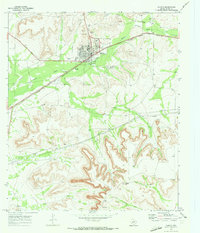
1970 Map of Rankin
USGS Topo · Published 1973About this map
Rankin serves as the focal point of this 1970s West Texas landscape, positioned where the Atchison Topeka and Santa Fe railroad crosses the terrain. The town shows a developed community infrastructure including a High Sch, a Hospital, and localized leisure sites like a Drive-in Theater, Golf Course, and the Duo Day Arena. The surrounding Upton County plains are heavily marked by the energy and transportation industries, with numerous Oil Wells, Drill Holes, and an extensive network of Pipelines and Pipelines traversing the area.
Find a feature on this map
27 named features on this map. Tap any name to fly to it.
Don’t see what you’re looking for? This feature index may not catch every label — zoom into the map to look around manually.
Map Details
Editions of this 1970 Rankin Map
2 editions found
Other maps of this area

1928 · Crane
USGS Topo · 1:125,000

1928 · Rankin
USGS Topo · 1:125,000

1954 · Pecos
USGS Topo · 1:250,000

1954 · San Angelo
USGS Topo · 1:250,000

1957 · Pecos
USGS Topo · 1:250,000

1958 · San Angelo
USGS Topo · 1:250,000

1965 · San Angelo
USGS Topo · 1:250,000

1970 · Sevenmile Corner SE
USGS Topo · 1:24,000
1970 · Rankin SE
USGS Topo · 1:24,000
1970 · Cedar Canyon
USGS Topo · 1:24,000