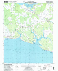
1997 Map of Ransomville
USGS Topo · Published 2001About this map
Pamlico River frontage and intricate marshlands define this coastal landscape on the northern shore of the estuary. The area shows a transition from the dense, wet terrain of Jackson Swamp in the west to the more open Woodstock Savanna further east. Small inland settlements like Ransomville and Winsteadville are connected by rural routes such as Woodstock Road and Wheat Patch Road, reflecting a pattern of historic timber and agricultural land use.
Find a feature on this map
57 named features on this map. Tap any name to fly to it.
Don’t see what you’re looking for? This feature index may not catch every label — zoom into the map to look around manually.
Map Details
Editions of this 1997 Ransomville Map
This is the sole edition of this map. No revisions or reprints were ever made.
Other maps of this area

1914 · Belhaven
USGS Topo · 1:48,000

1916 · Belhaven
USGS Topo · 1:62,500

1943 · Plymouth
USGS Topo · 1:125,000

1950 · Lowland
USGS Topo · 1:24,000

1950 · South Creek
USGS Topo · 1:24,000

1950 · Pinetown
USGS Topo · 1:24,000

1950 · Aurora
USGS Topo · 1:24,000

1951 · Bath
USGS Topo · 1:24,000

1951 · Ransomville
USGS Topo · 1:24,000

1951 · Pamlico Beach
USGS Topo · 1:24,000