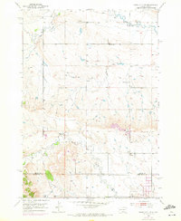
1953 Map of Rapid City NW
USGS Topo · Published 1972About this map
The prairie landscape north of Rapid City, along the boundary of Meade and Pennington counties, reveals a mid-century rural network of community landmarks and watercourses. Elk Creek and Boxelder Creek wind through the terrain, anchoring a sparse but established settlement pattern of small schools and local gathering places. Central to the social geography are Harmony Sch, the Elk Creek Community Hall, and the Elk Vale Cem, which provide specific points of interest for genealogists tracing family roots in this corner of South Dakota.
Find a feature on this map
13 named features on this map. Tap any name to fly to it.
Don’t see what you’re looking for? This feature index may not catch every label — zoom into the map to look around manually.
Map Details
Editions of this 1953 Rapid City NW Map
3 editions found
Other maps of this area

1893 · Rapid
USGS Topo · 1:125,000

1898 · Rapid
USGS Topo · 1:125,000

1903 · Rapid
USGS Topo · 1:125,000

1953 · Bend
USGS Topo · 1:24,000

1953 · Rapid City 1 SW
USGS Topo · 1:24,000

1953 · Boxelder
USGS Topo · 1:24,000

1953 · Blackhawk
USGS Topo · 1:24,000

1953 · Rapid City East
USGS Topo · 1:24,000

1953 · Rapid City NW
USGS Topo · 1:24,000

1953 · Rapid City West
USGS Topo · 1:24,000