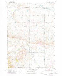
1953 Map of Rapid City NW
USGS Topo · Published 1977About this map
Elk Creek and Boxelder Creek wind through the West River landscape of the Black Hills foothills on this mid-century survey. The area exhibits a pattern of rural settlement focused on community institutions, with family and parish life centered around landmarks such as Holy Family Ch, the Elk Creek Community Hall, and the Elk Vale Cem. The map captures a transition in local education, showing active sites like Harmony Sch and Fairview Sch alongside the already School No 3 (Abandoned). Crossing the Meade and Pennington County line, the terrain is marked by numerous Gravel Pits, pointing to the local infrastructure needs of the 1950s. Purple photorevised updates from 1971 show the expansion of the road network and new building footprints, layered over the original 1953 topography.
Find a feature on this map
11 named features on this map. Tap any name to fly to it.
Don’t see what you’re looking for? This feature index may not catch every label — zoom into the map to look around manually.
Map Details
Editions of this 1953 Rapid City NW Map
3 editions found
Other maps of this area

1893 · Rapid
USGS Topo · 1:125,000

1898 · Rapid
USGS Topo · 1:125,000

1903 · Rapid
USGS Topo · 1:125,000

1953 · Bend
USGS Topo · 1:24,000

1953 · Rapid City 1 SW
USGS Topo · 1:24,000

1953 · Boxelder
USGS Topo · 1:24,000

1953 · Blackhawk
USGS Topo · 1:24,000

1953 · Rapid City East
USGS Topo · 1:24,000

1953 · Rapid City NW
USGS Topo · 1:24,000

1953 · Rapid City West
USGS Topo · 1:24,000