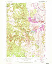
1953 Map of Rapid City West
USGS Topo · Published 1972About this map
Black Hills National Forest dominates the western half of this landscape, where the terrain is deeply carved by drainages like Wild Irishman Gulch and Cleghorn Canyon. To the east, the mid-century expansion of Rapid City begins to press against the limestone ridges. The urban fringe is marked by essential local institutions, including the Sioux Sanatorium, Bennett Clarkson Hospital, and Camp Rapid. These 1953 field-checked records show a dense network of rural education, with small schoolhouses such as Doty Sch, Winther Sch, and Whispering Pine Sch serving outlying homesteads and mountain valleys.
Find a feature on this map
45 named features on this map. Tap any name to fly to it.
Don’t see what you’re looking for? This feature index may not catch every label — zoom into the map to look around manually.
Map Details
Editions of this 1953 Rapid City West Map
4 editions found

Other maps of this area

1893 · Rapid
USGS Topo · 1:125,000

1894 · Hermosa
USGS Topo · 1:125,000

1898 · Rapid
USGS Topo · 1:125,000

1901 · Hermosa
USGS Topo · 1:125,000

1903 · Rapid
USGS Topo · 1:125,000

1953 · Hermosa NW
USGS Topo · 1:24,000

1953 · Blackhawk
USGS Topo · 1:24,000

1953 · Rapid City East
USGS Topo · 1:24,000

1953 · Piedmont
USGS Topo · 1:24,000

1953 · Rapid City NW
USGS Topo · 1:24,000
Featured Places
- Rapid City, SD
- South Canyon Country Estates, SD
- Clarkson Addition, SD
- Schaeferville, SD
- Wildwood Addition, Rapid City