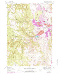
1953 Map of Rapid City West
USGS Topo · Published 1978About this map
Rapid City and its western fringe are captured here in a period of significant mid-century expansion into the foothills. The map reveals the institutional and civic landscape of the era, from the grounds of Camp Rapid to the Sioux Sanitarium and Bennett Clarkson Hospital. Education is well-represented by a network of rural and suburban schoolhouses including Doty Sch, Winther Sch, and Whispering Pine Sch. This survey highlights the transition from the concentrated urban core near the Chicago and North Western railroad to the recreation-oriented outskirts.
Find a feature on this map
44 named features on this map. Tap any name to fly to it.
Don’t see what you’re looking for? This feature index may not catch every label — zoom into the map to look around manually.
Map Details
Editions of this 1953 Rapid City West Map
4 editions found

Other maps of this area

1893 · Rapid
USGS Topo · 1:125,000

1894 · Hermosa
USGS Topo · 1:125,000

1898 · Rapid
USGS Topo · 1:125,000

1901 · Hermosa
USGS Topo · 1:125,000

1903 · Rapid
USGS Topo · 1:125,000

1953 · Hermosa NW
USGS Topo · 1:24,000

1953 · Blackhawk
USGS Topo · 1:24,000

1953 · Rapid City East
USGS Topo · 1:24,000

1953 · Piedmont
USGS Topo · 1:24,000

1953 · Rapid City NW
USGS Topo · 1:24,000
Featured Places
- Rapid City, SD
- South Canyon Country Estates, SD
- Clarkson Addition, SD
- Schaeferville, SD
- Wildwood Addition, Rapid City