
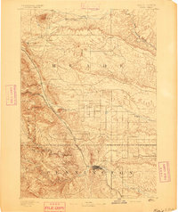
1893 Map of Rapid
USGS Topo · Published 1893About this map
Fort Meade stands as a prominent military installation in the northwest, serving as a focal point for this early Dakotas frontier landscape. The settlement of Rapid is established at the intersection of the foothills and the plains, where Rapid Creek emerges from the steep gulches of the Black Hills. Two major rail lines, the Fremont Elkhorn and Missouri Valley Railroad and the Black Hills and Fort Pierre Railroad, trace the eastern edge of the mountains, facilitating movement between settlements like Piedmont and Tilford.
Find a feature on this map
36 named features on this map. Tap any name to fly to it.
Don’t see what you’re looking for? This feature index may not catch every label — zoom into the map to look around manually.
Map Details
Editions of this 1893 Rapid Map
2 editions found
Other maps of this area

1894 · Deadwood
USGS Topo · 1:125,000

1894 · Hermosa
USGS Topo · 1:125,000

1896 · Harney Peak
USGS Topo · 1:125,000

1898 · Rapid
USGS Topo · 1:125,000

1899 · Sturgis
USGS Topo · 1:62,500

1901 · Hermosa
USGS Topo · 1:125,000

1901 · Harney Peak
USGS Topo · 1:125,000

1901 · Deadwood
USGS Topo · 1:125,000

1903 · Rapid
USGS Topo · 1:125,000

1905 · Saint Onge
USGS Topo · 1:62,500