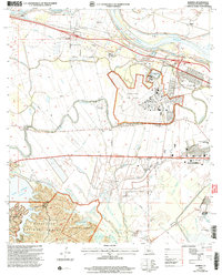
2003 Map of Rapides
USGS Topo · Published 2005About this map
The Red River floodplain dominates the northern half of this landscape, where a complex network of levees and bayous such as Bertrand Bayou and Big Bayou protects agricultural lands and rural settlements. Near the river, the State/FS Welcome Center and several local congregations like St Matthews Ch and Methodist Ch anchor the community of Rapides. The presence of the England Air Park and the Central Louisiana State Hospital highlights the area's institutional and military infrastructure as Alexandria begins to expand westward.
Find a feature on this map
54 named features on this map. Tap any name to fly to it.
Don’t see what you’re looking for? This feature index may not catch every label — zoom into the map to look around manually.
Map Details
Editions of this 2003 Rapides Map
This is the sole edition of this map. No revisions or reprints were ever made.
Other maps of this area

1932 · Boyce NE
USGS Topo · 1:31,680

1932 · Boyce SW
USGS Topo · 1:31,680

1935 · Lecompte
USGS Topo · 1:62,500

1941 · Alexandria
USGS Topo · 1:62,500

1941 · Boyce
USGS Topo · 1:62,500

1945 · Boyce SE
USGS Topo · 1:31,680

1949 · Boyce NW
USGS Topo · 1:31,680

1949 · Boyce SE
USGS Topo · 1:31,680

1953 · Alexandria
USGS Topo · 1:250,000

1955 · Alexandria
USGS Topo · 1:250,000