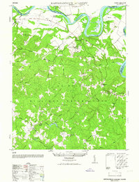
1952 Map of Rappahannock Academy
USGS Topo · Published 1952About this map
The A P Hill Military Reservation dominates this 1952 civil reprint of a wartime survey, illustrating the transformation of the Caroline County landscape as military operations integrated with the existing rural structure. Extensive road networks such as Burma Road and Engineer Road weave through terrain marked by historic family-named junctions like Bullocks Corner and Samuels Corner. The presence of Moss Neck Manor and the nearby Moss Neck Airstrip suggests the intersection of traditional Virginia estates with mid-century aviation and defense needs. Along the northern boundary, the Rappahannock River meanders around Skinkers Neck, providing a natural contrast to the grid of training areas and reservations. Local genealogy is anchored by landmarks like Bethesda Church, Liberty Church, and Travis Mill, alongside several clusters of ruins that hint at the area's earlier agricultural and social life before federal acquisition.
Find a feature on this map
51 named features on this map. Tap any name to fly to it.
Don’t see what you’re looking for? This feature index may not catch every label — zoom into the map to look around manually.
Map Details
Editions of this 1952 Rappahannock Academy Map
This is the sole edition of this map. No revisions or reprints were ever made.
Other maps of this area

1889 · Fredericksburg
USGS Topo · 1:125,000

1892 · Fredericksburg
USGS Topo · 1:125,000

1894 · Fredericksburg
USGS Topo · 1:125,000

1926 · Stafford
USGS Topo · 1:62,500

1931 · Stafford
USGS Topo · 1:62,500

1942 · Bowling Green
USGS Topo · 1:31,680

1942 · Upper Zion
USGS Topo · 1:31,680

1942 · Woodford
USGS Topo · 1:31,680

1942 · Guinea
USGS Topo · 1:31,680

1942 · Port Royal
USGS Topo · 1:31,680