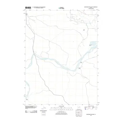
2011 Map of Rasmussen Hollow
USGS Topo · Published 2011About this map
Green River dominates this arid landscape as it winds through the south, carved into deep topographical depressions such as Walker Hollow and Spring Hollow. The map captures a transition from the riparian corridor of the river to the elevated terrain of Ashley Valley in the north. This area is characterized by a sparse road network, including Goose Ranch Rd and Redwash Hwy, which connect the scattered agricultural and ranching interests found along the Ashley Creek drainage. The inclusion of Rasmussen Hollow and Baser Wash highlights the intricate drainage patterns that define this high desert environment, where water access dictated the placement of early travel routes and ranch boundaries.
Find a feature on this map
15 named features on this map. Tap any name to fly to it.
Don’t see what you’re looking for? This feature index may not catch every label — zoom into the map to look around manually.
Map Details
Editions of this 2011 Rasmussen Hollow Map
This is the sole edition of this map. No revisions or reprints were ever made.
Other maps of this area

1885 · Ashley
USGS Topo · 1:250,000

1907 · Jensen
USGS Topo · 1:125,000

1910 · Jensen
USGS Topo · 1:125,000

1917 · Vernal
USGS Topo · 1:125,000

1954 · Vernal
USGS Topo · 1:250,000

1958 · Vernal
USGS Topo · 1:250,000

1960 · Vernal
USGS Topo · 1:250,000

1964 · Vernal NE
USGS Topo · 1:24,000

1964 · Brennan Basin
USGS Topo · 1:24,000
1964 · Vernal SE
USGS Topo · 1:24,000