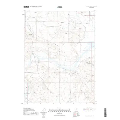
2020 Map of Rasmussen Hollow
USGS Topo · Published 2020About this map
The Green River carves a sweeping path through this Uintah County landscape, defining the transition from the irrigated expanses of Ashley Valley to the uplifted terrain of Asphalt Ridge. This survey captures a mix of traditional ranching infrastructure and modern aviation, highlighted by the presence of Sundog Airport in the northeastern reaches. The intricate network of rural routes, including Alahandra Ferry Rd and Geo Slaugh Ranch Rd, reveals the enduring ranching heritage of the region. Deep ravines such as Mantle Gulch and Rasmussen Hollow drain toward the river, while distinct topographical features like the prominent Horseshoe Bend and the tributary Ashley Cr illustrate the complex fluvial geomorphology of the basin. This map serves as a vital record of the county's water access and land use patterns as they existed in the early 21st century.
Find a feature on this map
26 named features on this map. Tap any name to fly to it.
Don’t see what you’re looking for? This feature index may not catch every label — zoom into the map to look around manually.
Map Details
Editions of this 2020 Rasmussen Hollow Map
This is the sole edition of this map. No revisions or reprints were ever made.
Other maps of this area

1885 · Ashley
USGS Topo · 1:250,000

1907 · Jensen
USGS Topo · 1:125,000

1910 · Jensen
USGS Topo · 1:125,000

1917 · Vernal
USGS Topo · 1:125,000

1954 · Vernal
USGS Topo · 1:250,000

1958 · Vernal
USGS Topo · 1:250,000

1960 · Vernal
USGS Topo · 1:250,000

1964 · Vernal NE
USGS Topo · 1:24,000

1964 · Brennan Basin
USGS Topo · 1:24,000
1964 · Vernal SE
USGS Topo · 1:24,000