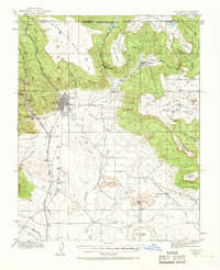
1912 Map of Raton
USGS Topo · Published 1968About this map
Raton serves as the gateway between the high mesas of the Colorado border and the plains of New Mexico, dominated by the industrial infrastructure of the Atchison Topeka and Santa Fe Railroad. This 1912 survey illustrates a landscape shaped by coal and transit, from the critical Raton Tunnel at the northern pass to the scattered mining and settlement nodes like Gardiner, Blossburg, and Yankee. The intricate topography of Bartlett Mesa and Johnson Mesa constrains development to the valleys, where the Scenic Highway and rail lines follow the path of Raton Creek. Local industry is evidenced by the Wagon Mine and the water systems of Lake Alice and the Reservoir near Sugarite. Genealogists may find value in tracing older landmarks like Clifton House and Otero, which reflect the early settlement patterns of Colfax County before the turn of the century.
Find a feature on this map
50 named features on this map. Tap any name to fly to it.
Don’t see what you’re looking for? This feature index may not catch every label — zoom into the map to look around manually.
Map Details
Editions of this 1912 Raton Map
2 editions found
Other maps of this area

1891 · Spanish Peaks
USGS Topo · 1:125,000

1892 · Elmoro
USGS Topo · 1:125,000

1893 · Spanish Peaks
USGS Topo · 1:125,000

1893 · Elmoro
USGS Topo · 1:125,000

1895 · Spanish Peaks
USGS Topo · 1:125,000

1897 · Elmoro
USGS Topo · 1:125,000

1897 · Spanish Peaks
USGS Topo · 1:125,000

1900 · Spanish Peaks
USGS Topo · 1:125,000

1912 · Raton
USGS Topo · 1:62,500

1914 · Raton
USGS Topo · 1:62,500