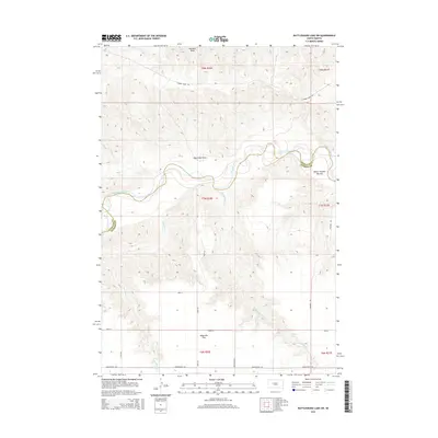
2015 Map of Rattlesnake Lake SW
USGS Topo · Published 2015About this map
The Cheyenne River winds through this South Dakota landscape, marking the boundary between Ziebach and Haakon counties. The river valley is defined by distinct topographical zones like White Thunder Bottom and the broad, open expanse of Milesville Flat to the south. Tributaries such as Bull Cr, Harding Cr, and Straighthead Cr carve through the terrain, creating localized drainages including Black Bull Draw and Red Bull Draw.
Find a feature on this map
23 named features on this map. Tap any name to fly to it.
Don’t see what you’re looking for? This feature index may not catch every label — zoom into the map to look around manually.
Map Details
Editions of this 2015 Rattlesnake Lake SW Map
This is the sole edition of this map. No revisions or reprints were ever made.
Other maps of this area

1954 · Pierre
USGS Topo · 1:250,000

1955 · Rattlesnake Lake SE
USGS Topo · 1:24,000

1955 · Rattlesnake Lake SW
USGS Topo · 1:24,000

1955 · Rattlesnake Lake
USGS Topo · 1:24,000

1955 · Rattlesnake Lake NE
USGS Topo · 1:24,000

1955 · Bridger SE
USGS Topo · 1:24,000

1958 · Pierre
USGS Topo · 1:250,000

1982 · Bridger NE
USGS Topo · 1:24,000

1983 · Philip
USGS Topo · 1:100,000
1983 · Hartley
USGS Topo · 1:24,000