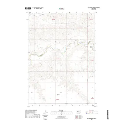
2017 Map of Rattlesnake Lake SW
USGS Topo · Published 2017About this map
The Cheyenne River winds through the heart of this West River landscape, defining the jagged boundary between Ziebach and Haakon Counties. The terrain transitions from the broad, level expanse of Milesville Flat in the south to the intricately eroded breaks and draws of the river valley. Landmarks like White Thunder Bottom and the convergence of Straighthead Cr with the main channel reveal a landscape shaped by hydrology and cattle ranching. A sparse network of section-line roads, including Hardingrove Rd and 217th Ave, provides access to the remote uplands and draws. The presence of BIA Hwy 8 in the north indicates proximity to tribal lands, while named features such as Red Bull Draw and Black Bull Draw underscore the region's enduring ranching identity.
Find a feature on this map
24 named features on this map. Tap any name to fly to it.
Don’t see what you’re looking for? This feature index may not catch every label — zoom into the map to look around manually.
Map Details
Editions of this 2017 Rattlesnake Lake SW Map
This is the sole edition of this map. No revisions or reprints were ever made.
Other maps of this area

1954 · Pierre
USGS Topo · 1:250,000

1955 · Rattlesnake Lake SE
USGS Topo · 1:24,000

1955 · Rattlesnake Lake SW
USGS Topo · 1:24,000

1955 · Rattlesnake Lake
USGS Topo · 1:24,000

1955 · Rattlesnake Lake NE
USGS Topo · 1:24,000

1955 · Bridger SE
USGS Topo · 1:24,000

1958 · Pierre
USGS Topo · 1:250,000

1982 · Bridger NE
USGS Topo · 1:24,000

1983 · Philip
USGS Topo · 1:100,000
1983 · Hartley
USGS Topo · 1:24,000