
1955 Map of Rattlesnake Lake SW
USGS Topo · Published 1956About this map
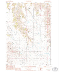
The Cheyenne River carves a winding path through this mid-century West River landscape, serving as the northern boundary for Ziebach and Haakon counties. This portion of the Cheyenne River Indian Reservation is defined by a series of dramatic draws and creeks, including Black Bull Draw and Bull Creek, which feed into the primary river valley. The map reveals the sparse educational infrastructure of the period, noting the Harding Grove Sch and the already Elshers Sch (Abandoned), documenting a shift in rural settlement patterns as families moved away from isolated homesteads. The vast, level expanse of Milesville Flat in the south provides a sharp contrast to the dissected breaks of Straighthead Creek and the low-lying White Thunder Bottom near the river’s edge.
Find a feature on this map
13 named features on this map. Tap any name to fly to it.
Don’t see what you’re looking for? This feature index may not catch every label — zoom into the map to look around manually.
Map Details
Editions of this 1955 Rattlesnake Lake SW Map
This is the sole edition of this map. No revisions or reprints were ever made.
Other maps of this area

1954 · Pierre
USGS Topo · 1:250,000

1955 · Rattlesnake Lake SE
USGS Topo · 1:24,000

1955 · Rattlesnake Lake
USGS Topo · 1:24,000

1955 · Rattlesnake Lake NE
USGS Topo · 1:24,000

1955 · Bridger SE
USGS Topo · 1:24,000

1958 · Pierre
USGS Topo · 1:250,000

1982 · Bridger NE
USGS Topo · 1:24,000

1983 · Philip
USGS Topo · 1:100,000
1983 · Hartley
USGS Topo · 1:24,000

1983 · Milesville
USGS Topo · 1:24,000