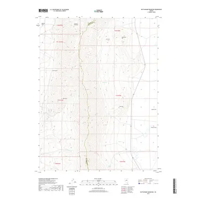
2018 Map of Rattlesnake Mountain
USGS Topo · Published 2018About this map
The Diamond Mountains dominate this high-desert landscape, forming a dramatic physical boundary between the arid basins of Diamond Valley to the west and the expansive Newark Valley to the east. This 2018 survey documents a remote portion of the Eureka Co White Pine Co line as it traverses the ridgeline. Water sources are scarce but critical in this terrain, marked by scattered features such as Willow Spring, Robinson Springs, and seasonal drainages like Pedrioli Cr and Minoletti Cr. Notable landmarks include the namesake Rattlesnake Mtn, the high prominence of Cedar Mtn, and the secluded basin of Fairy Dell. Along the eastern edge, the map captures the transition to the playa of Newark Lake, illustrating the stark hydrology of the Great Basin.
Find a feature on this map
22 named features on this map. Tap any name to fly to it.
Don’t see what you’re looking for? This feature index may not catch every label — zoom into the map to look around manually.
Map Details
Editions of this 2018 Rattlesnake Mountain Map
This is the sole edition of this map. No revisions or reprints were ever made.
Other maps of this area

1953 · Eureka
USGS Topo · 1:62,500

1956 · Ely
USGS Topo · 1:250,000

1957 · Buck Mountain
USGS Topo · 1:62,500

1957 · Diamond Springs
USGS Topo · 1:62,500

1957 · Cold Creek Ranch
USGS Topo · 1:62,500

1959 · Ely
USGS Topo · 1:250,000

1963 · Ely
USGS Topo · 1:250,000

1985 · Newark Lake
USGS Topo · 1:100,000
1990 · North of Eureka
USGS Topo · 1:24,000
1990 · Diamond Peak
USGS Topo · 1:24,000