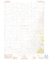
1990 Map of North of Eureka
USGS Topo · Published 1990About this map
Diamond Valley dominates this 1990 provisional survey of central Nevada, where the flat valley floor meets the rising slopes of the Diamond Mountains. This high-desert landscape is characterized by intermittent drainage patterns, with several named waterways such as Pedrioli Creek, Minoletti Creek, Cottonwood Creek, and Slough Creek flowing from the eastern heights toward the valley center. The map reflects a region defined by agricultural and industrial efforts, marked by numerous wells and a scattered Gravel Pit. The eastern edge is defined by steep elevation changes, particularly around Green Canyon, illustrating the transition from the alluvial fans of the valley to the rugged mountain range. These features point to the importance of water management and resource extraction in this part of Eureka County during the late twentieth century.
Find a feature on this map
12 named features on this map. Tap any name to fly to it.
Don’t see what you’re looking for? This feature index may not catch every label — zoom into the map to look around manually.
Map Details
Editions of this 1990 North of Eureka Map
This is the sole edition of this map. No revisions or reprints were ever made.
Other maps of this area

1926 · Roberts Mountains
USGS Topo · 1:250,000

1929 · Roberts Mountains
USGS Topo · 1:250,000

1949 · Garden Valley
USGS Topo · 1:62,500

1951 · Garden Valley
USGS Topo · 1:62,500

1953 · Eureka
USGS Topo · 1:62,500

1955 · Millett
USGS Topo · 1:250,000

1956 · Whistler Mtn
USGS Topo · 1:62,500

1956 · Ely
USGS Topo · 1:250,000

1957 · Diamond Springs
USGS Topo · 1:62,500

1959 · Ely
USGS Topo · 1:250,000