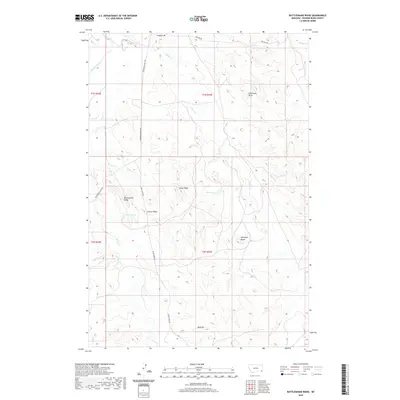
2020 Map of Rattlesnake Ridge
USGS Topo · Published 2020About this map
Rattlesnake Ridge and Sixmile Ridge dominate this high-plains landscape in southeastern Montana. The terrain is defined by a network of drainage systems feeding into the Powder River at the northwestern corner of the sheet. Names like Soldiers Mt and Antelope Butte suggest the distinct topographical landmarks used for navigation in this open country. Human presence is marked by a grid of rural routes including Powderville East Rd and Crow Creek Rd, which follow the natural contours of the ridges and creek valleys. Notable water sources such as Dunbar Spring and the Trout Pond provide vital points of interest in an area characterized by seasonal drainage through Flintheart Draw and various creek beds like Timber Cr and Crow Cr.
Find a feature on this map
25 named features on this map. Tap any name to fly to it.
Don’t see what you’re looking for? This feature index may not catch every label — zoom into the map to look around manually.
Map Details
Editions of this 2020 Rattlesnake Ridge Map
This is the sole edition of this map. No revisions or reprints were ever made.
Other maps of this area

1954 · Ekalaka
USGS Topo · 1:250,000

1956 · Ekalaka
USGS Topo · 1:250,000

1958 · Ekalaka
USGS Topo · 1:250,000

1965 · Ekalaka
USGS Topo · 1:250,000

1979 · Deer Creek Buttes
USGS Topo · 1:24,000

1979 · Blacktail Creek SW
USGS Topo · 1:24,000

1979 · Powderville
USGS Topo · 1:24,000

1979 · Rattlesnake Ridge
USGS Topo · 1:24,000
1979 · Oliphant Butte
USGS Topo · 1:24,000

1979 · McKenzie Creek
USGS Topo · 1:24,000