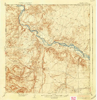
1937 Map of Rattlesnake
USGS Topo · Published 1937About this map
The San Juan River carves a broad path across this high desert landscape, serving as the primary geographical anchor for the northwest corner of New Mexico during the mid-1930s. This survey, conducted by R.H. Reineck and R.A. Kiger, details a sparsely populated expanse of the Navajo Indian Reservation near the iconic Four Corners junction where Arizona, Colorado, and New Mexico meet.
Find a feature on this map
15 named features on this map. Tap any name to fly to it.
Don’t see what you’re looking for? This feature index may not catch every label — zoom into the map to look around manually.
Map Details
Editions of this 1937 Rattlesnake Map
3 editions found

Other maps of this area

1886 · Abajo
USGS Topo · 1:250,000

1889 · Chaco
USGS Topo · 1:250,000

1892 · Abajo
USGS Topo · 1:250,000

1892 · Chaco
USGS Topo · 1:250,000

1892 · Canyon De Chelly
USGS Topo · 1:250,000

1893 · Abajo
USGS Topo · 1:250,000

1927 · Sulphur Spring
USGS Topo · 1:96,000

1928 · Kirtland
USGS Topo · 1:125,000

1932 · Kirtland
USGS Topo · 1:125,000

1934 · Ship Rock
USGS Topo · 1:62,500
Featured Places
- Shiprock Agency
- Gadii'ahi, Shiprock Agency
- Rattlesnake, Shiprock Agency
- San Juan County, NM
- Montezuma County, CO