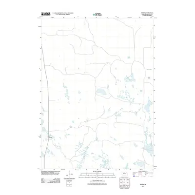
2011 Map of Raven
USGS Topo · Published 2011About this map
Raven is the central settlement in this sparsely populated stretch of the Nebraska Sandhills, located within Brown County. The landscape is defined by its numerous small, unnamed basins and wetlands characteristic of this unique geographic region. Two named water bodies, Jones Lake and Hagan Lake, stand out against the high-density distribution of smaller potholes and seasonal pools. Transportation and access are facilitated by a network of local roads and the inclusion of Abbott Airport, which serves this isolated ranching country. The distribution of these features reveals a pattern of land use centered on a few reliable water sources and the necessary infrastructure for reaching this corner of the Great Plains. The map provides a clear look at the area's hydrology and small-scale settlement patterns as they existed in the early twenty-first century.
Find a feature on this map
4 named features on this map. Tap any name to fly to it.
Don’t see what you’re looking for? This feature index may not catch every label — zoom into the map to look around manually.
Map Details
Editions of this 2011 Raven Map
This is the sole edition of this map. No revisions or reprints were ever made.
Other maps of this area

1955 · O'Neill
USGS Topo · 1:250,000

1959 · O'Neill
USGS Topo · 1:250,000

1969 · O'Neill
USGS Topo · 1:250,000

1981 · Paramount Valley
USGS Topo · 1:24,000

1982 · Lost Lake Ranch
USGS Topo · 1:24,000

1982 · Hofeld Lake
USGS Topo · 1:24,000

1982 · Raven
USGS Topo · 1:24,000
1982 · Goldman Lake NW
USGS Topo · 1:24,000
1982 · Goldman Lake NE
USGS Topo · 1:24,000
1982 · Raven SW
USGS Topo · 1:24,000