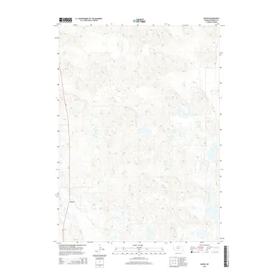
2014 Map of Raven
USGS Topo · Published 2014About this map
Raven sits along the western edge of this Nebraska Sandhills landscape, where the terrain is defined by a dense network of dunes and depressions typical of Brown County. The map captures a primarily rural and topographic view of the region in the early 21st century, dominated by natural hydrology and subtle elevation changes rather than dense infrastructure. Aside from the small cluster at Raven, the primary human footprint is found along Ne-7, which cuts through the sandy hills. Water features like Jones Lake dot the low-lying areas between the dunes, representing the scattered prairie lakes that characterize this portion of the Great Plains. This 2014 survey provides a clear look at the sparsely populated environment, useful for understanding the modern distribution of family ranching lands and isolated settlements in north-central Nebraska.
Find a feature on this map
3 named features on this map. Tap any name to fly to it.
Don’t see what you’re looking for? This feature index may not catch every label — zoom into the map to look around manually.
Map Details
Editions of this 2014 Raven Map
This is the sole edition of this map. No revisions or reprints were ever made.
Other maps of this area

1955 · O'Neill
USGS Topo · 1:250,000

1959 · O'Neill
USGS Topo · 1:250,000

1969 · O'Neill
USGS Topo · 1:250,000

1981 · Paramount Valley
USGS Topo · 1:24,000

1982 · Lost Lake Ranch
USGS Topo · 1:24,000

1982 · Hofeld Lake
USGS Topo · 1:24,000

1982 · Raven
USGS Topo · 1:24,000
1982 · Goldman Lake NW
USGS Topo · 1:24,000
1982 · Goldman Lake NE
USGS Topo · 1:24,000
1982 · Raven SW
USGS Topo · 1:24,000