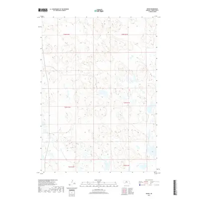
2017 Map of Raven
USGS Topo · Published 2017About this map
Jones Lake and Hagan Lake define the hydrology of this Sandhills landscape in Brown County. The map details a sparsely populated ranching region organized by the Public Land Survey System, including portions of townships t28n r22w, t28n r21w, t27n r22w, t27n r21w, t26n r22w, and t26n r21w. This area is characterized by an intricate network of wetlands and small water bodies that pocket the undulating terrain, typical of the Nebraska interior during the early 21st century. The absence of traditional town centers highlights the rural, agricultural nature of the territory, where land use is primarily dictated by the natural distribution of water across the various sections.
Find a feature on this map
8 named features on this map. Tap any name to fly to it.
Don’t see what you’re looking for? This feature index may not catch every label — zoom into the map to look around manually.
Map Details
Editions of this 2017 Raven Map
This is the sole edition of this map. No revisions or reprints were ever made.
Other maps of this area

1955 · O'Neill
USGS Topo · 1:250,000

1959 · O'Neill
USGS Topo · 1:250,000

1969 · O'Neill
USGS Topo · 1:250,000

1981 · Paramount Valley
USGS Topo · 1:24,000

1982 · Lost Lake Ranch
USGS Topo · 1:24,000

1982 · Hofeld Lake
USGS Topo · 1:24,000

1982 · Raven
USGS Topo · 1:24,000
1982 · Goldman Lake NW
USGS Topo · 1:24,000
1982 · Goldman Lake NE
USGS Topo · 1:24,000
1982 · Raven SW
USGS Topo · 1:24,000