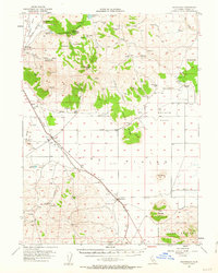
1954 Map of Ravendale
USGS Topo · Published 1963About this map
Madeline Plains defines the lower elevations of this high-desert basin, where the Southern Pacific railroad parallels the highway through the small settlements of Termo and Ravendale. The landscape is shaped by the ranching economy of the mid-1950s, evidenced by numerous named family sites such as Mendiboure Ranch, Jones Ranch, and Harry Marr Ranch. Water management is central to life here, with the map recording a network of springs and reservoirs like Van Loan Reservoir and Etchecopar Spr feeding the arid flats.
Find a feature on this map
50 named features on this map. Tap any name to fly to it.
Don’t see what you’re looking for? This feature index may not catch every label — zoom into the map to look around manually.
Map Details
Editions of this 1954 Ravendale Map
3 editions found
Other maps of this area

1886 · Alturas
USGS Topo · 1:250,000

1886 · Honey Lake
USGS Topo · 1:250,000

1891 · Honey Lake
USGS Topo · 1:250,000

1892 · Alturas
USGS Topo · 1:250,000

1893 · Honey Lake
USGS Topo · 1:250,000

1954 · Observation Peak
USGS Topo · 1:62,500

1954 · Karlo
USGS Topo · 1:62,500

1954 · Grasshopper Valley
USGS Topo · 1:62,500

1954 · Ravendale
USGS Topo · 1:62,500

1954 · Fredonyer Peak
USGS Topo · 1:62,500