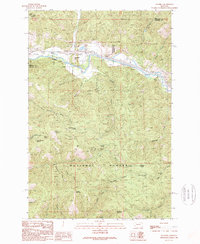
1989 Map of Ravenna
USGS Topo · Published 1989About this map
The Clark Fork river valley serves as the central artery for this late-20th-century topographic record, where the Montana mountain landscape meets industrial and recreational infrastructure. The corridor is defined by the heavy infrastructure of the Beavertail Tunnels and Nimrod Tunnels, facilitating transport through the steep terrain between Bonita and Ravenna. Most of the land falls within the Lolo National Forest, where numerous named gulches like Corona Gulch and Mason Gulch drain toward the river. Local landmarks such as Beavertail Hill Campground and Mormon Spring highlight the intersection of public land use and natural resources. Notable elevations like Golden Mountain and Strawberry Mountain frame the horizon, while smaller features like the Gravel Pit and various saddles provide insight into the specific land management and navigation patterns of the Granite and Missoula County border.
Find a feature on this map
44 named features on this map. Tap any name to fly to it.
Don’t see what you’re looking for? This feature index may not catch every label — zoom into the map to look around manually.
Map Details
Editions of this 1989 Ravenna Map
This is the sole edition of this map. No revisions or reprints were ever made.
Other maps of this area

1903 · Bonner
USGS Topo · 1:125,000

1919 · Drummond
USGS Topo · 1:125,000

1921 · Drummond
USGS Topo · 1:125,000

1947 · Butte
USGS Topo · 1:250,000

1958 · Butte
USGS Topo · 1:250,000

1959 · Bearmouth
USGS Topo · 1:62,500

1959 · Ravenna
USGS Topo · 1:62,500

1960 · Butte
USGS Topo · 1:250,000

1962 · Butte
USGS Topo · 1:250,000

1965 · Union Peak
USGS Topo · 1:24,000