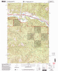
1999 Map of Ravenna
USGS Topo · Published 2003About this map
The Clark Fork river valley serves as the primary corridor for transportation and settlement in this late 20th-century survey of the boundary between Missoula and Granite counties. The small communities of Bonita and Ravenna are situated along the river, which is paralleled by major infrastructure including a pipeline and the Beavertail Hill Tunnels. Much of the southern and central terrain is dominated by the Lolo National Forest, characterized by high-elevation landmarks such as Burnt Mountain and Strawberry Mountain.
Find a feature on this map
44 named features on this map. Tap any name to fly to it.
Don’t see what you’re looking for? This feature index may not catch every label — zoom into the map to look around manually.
Map Details
Editions of this 1999 Ravenna Map
This is the sole edition of this map. No revisions or reprints were ever made.
Other maps of this area

1903 · Bonner
USGS Topo · 1:125,000

1919 · Drummond
USGS Topo · 1:125,000

1921 · Drummond
USGS Topo · 1:125,000

1947 · Butte
USGS Topo · 1:250,000

1958 · Butte
USGS Topo · 1:250,000

1959 · Bearmouth
USGS Topo · 1:62,500

1959 · Ravenna
USGS Topo · 1:62,500

1960 · Butte
USGS Topo · 1:250,000

1962 · Butte
USGS Topo · 1:250,000

1965 · Union Peak
USGS Topo · 1:24,000