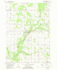
1980 Map of Ravenna
USGS Topo · Published 1980About this map
The village of Ravenna serves as the central hub of this West Michigan landscape, situated at the confluence of several rural townships including Moorland Township and Chester Township. The Grand Trunk Western railroad corridor bisects the terrain, illustrating the historical reliance on rail for transporting agricultural and industrial goods. Of particular interest is the Old Railroad Grade in the northern section, marking a former line that once connected timber and farming communities like Slocum and Moorland Corner.
Find a feature on this map
48 named features on this map. Tap any name to fly to it.
Don’t see what you’re looking for? This feature index may not catch every label — zoom into the map to look around manually.
Map Details
Editions of this 1980 Ravenna Map
This is the sole edition of this map. No revisions or reprints were ever made.
Other maps of this area

1930 · Muskegon
USGS Topo · 1:62,500

1936 · Muskegon
USGS Topo · 1:62,500

1945 · Ravenna
USGS Topo · 1:62,500

1954 · Milwaukee
USGS Topo · 1:250,000

1954 · Midland
USGS Topo · 1:250,000

1958 · Midland
USGS Topo · 1:250,000

1958 · Milwaukee
USGS Topo · 1:250,000

1958 · Twin Lake
USGS Topo · 1:62,500

1958 · Fremont
USGS Topo · 1:62,500

1959 · Midland
USGS Topo · 1:250,000