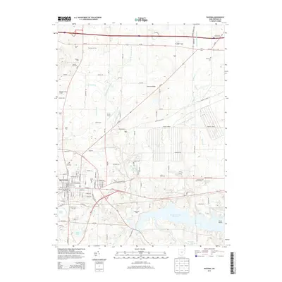
2013 Map of Ravenna
USGS Topo · Published 2013About this map
Ravenna and its surrounding agricultural outskirts appear here in a landscape defined by the upper reaches of the West Branch Mahoning River. The southern portion of the map is dominated by the sprawling Michael J Kirwan Reservoir, where Goose Island sits near the eastern shore. This 2013 survey illustrates a diverse rural economy, naming specialized operations like Alger Dairy and Desatnik Tree Farms, alongside numerous family-held lands such as Promise Land Farm and Heasley Farm. The map provides significant detail for local historians, marking various cemeteries like Maple Grove Cem and Drakesburg Cem. Aviation hubs are also visible, including the Portage County Airport and the smaller Jetway Airport located near Harmon Brook. Drainage features such as Crane Black Ditch and the Strawman-Fleming Ditch reveal the intensive land management required for the region's farms.
Find a feature on this map
114 named features on this map. Tap any name to fly to it.
Don’t see what you’re looking for? This feature index may not catch every label — zoom into the map to look around manually.
Map Details
Editions of this 2013 Ravenna Map
This is the sole edition of this map. No revisions or reprints were ever made.
Other maps of this area

1905 · Garrettsville
USGS Topo · 1:62,500

1906 · Kent
USGS Topo · 1:62,500

1906 · Chagrin Falls
USGS Topo · 1:62,500

1906 · Ravenna
USGS Topo · 1:62,500

1907 · Garrettsville
USGS Topo · 1:62,500

1908 · Chagrin Falls
USGS Topo · 1:62,500

1908 · Ravenna
USGS Topo · 1:62,500

1950 · Cleveland
USGS Topo · 1:250,000

1953 · Aurora
USGS Topo · 1:24,000

1956 · Cleveland
USGS Topo · 1:250,000