
1908 Map of Ravenswood
USGS Topo · Published 1908About this map
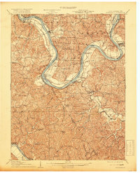
The Ohio River dominates this 1908 topographic survey, carving a massive horseshoe bend at Great Bend and passing through the dramatic Letart Falls. This river-oriented landscape, mapped just after the turn of the century, reveals a thriving network of early settlements and industrial points such as Hartford, New Haven, and Graham Station. Away from the main channel, the terrain is defined by complex drainages like Mill Creek and Sandy Creek, where rural life centered on local institutions. The distribution of numerous schoolhouses and churches, including the Hopedale School, Excelsior School, and Union Church, illustrates the density of these early hill communities before modern consolidation. Transport for the era is anchored by the K and M RR and the river commerce that linked West Virginia towns like Ravenswood to their Ohio neighbors in Meigs County.
Find a feature on this map
111 named features on this map. Tap any name to fly to it.
Don’t see what you’re looking for? This feature index may not catch every label — zoom into the map to look around manually.
Map Details
Editions of this 1908 Ravenswood Map
2 editions found
Other maps of this area

1906 · Belleville
USGS Topo · 1:62,500

1906 · Glenwood
USGS Topo · 1:62,500

1906 · Kenna
USGS Topo · 1:62,500

1906 · Winfield
USGS Topo · 1:62,500

1907 · Kenna
USGS Topo · 1:62,500

1907 · Pomeroy
USGS Topo · 1:62,500

1907 · Keno
USGS Topo · 1:62,500

1907 · Ripley
USGS Topo · 1:62,500

1908 · Glenwood
USGS Topo · 1:62,500

1908 · Winfield
USGS Topo · 1:62,500