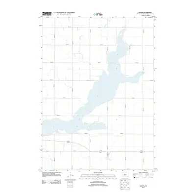
2012 Map of Ravinia
USGS Topo · Published 2012About this map
Lake Andes dominates this 2012 landscape in Charles Mix County, sprawling across a grid of rural section roads and township lines. The survey captures the intricate shoreline and surrounding hydrology as it existed shortly after the first decade of the millennium. The primary transportation artery is the combined route of US Highway 18 and 281, which cuts through the southern portion of the quadrangle near Elm Ave. This road network, defined by routes like 385th Ave and 390th Ave, reflects the persistent agrarian structure of the South Dakota plains. For researchers, the map provides a precise record of the lake's footprint and the local road designations such as 286th St and 294th St that facilitate movement through this prairie region.
Find a feature on this map
18 named features on this map. Tap any name to fly to it.
Don’t see what you’re looking for? This feature index may not catch every label — zoom into the map to look around manually.
Map Details
Editions of this 2012 Ravinia Map
This is the sole edition of this map. No revisions or reprints were ever made.
Other maps of this area

1955 · Mitchell
USGS Topo · 1:250,000

1959 · Mitchell
USGS Topo · 1:250,000

1964 · Wagner NE
USGS Topo · 1:24,000

1964 · Ravinia
USGS Topo · 1:24,000

1964 · Fort Randall Dam
USGS Topo · 1:24,000

1964 · Lake Andes
USGS Topo · 1:24,000

1964 · Wagner
USGS Topo · 1:24,000

1964 · Wagner SW
USGS Topo · 1:24,000
1977 · Wagner
USGS Topo · 1:24,000
1977 · Wagner SW
USGS Topo · 1:24,000
Featured Places
- Ravinia, SD
- White Swan Township, SD
- Goose Lake Township, SD
- Lake View Hutterite Colony, SD
- Howard Township, SD