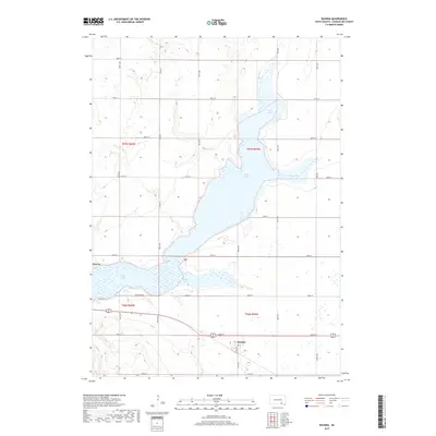
2017 Map of Ravinia
USGS Topo · Published 2017About this map
Lake Andes dominates this 2017 study of the South Dakota prairie, its complex shoreline defining the local geography with Johnson Bay reaching to the east and Owens Bay to the south. The small settlement of Ravinia is situated at the southern edge of the lake, organized around Elm Ave and Co Rd 21. Further west, the map identifies the locality of Dezera along the northern banks of the water. The landscape is marked by a precise section-line road grid, including Lakeshore Dr and numerous numbered avenues such as 388th Ave, which service the agricultural tracts surrounding the lake's marshy fringes. This survey provides a clear view of how the modern road network and rural settlements interface with the fluctuating hydrologic boundaries of the region.
Find a feature on this map
29 named features on this map. Tap any name to fly to it.
Don’t see what you’re looking for? This feature index may not catch every label — zoom into the map to look around manually.
Map Details
Editions of this 2017 Ravinia Map
This is the sole edition of this map. No revisions or reprints were ever made.
Other maps of this area

1955 · Mitchell
USGS Topo · 1:250,000

1959 · Mitchell
USGS Topo · 1:250,000

1964 · Wagner NE
USGS Topo · 1:24,000

1964 · Ravinia
USGS Topo · 1:24,000

1964 · Fort Randall Dam
USGS Topo · 1:24,000

1964 · Lake Andes
USGS Topo · 1:24,000

1964 · Wagner
USGS Topo · 1:24,000

1964 · Wagner SW
USGS Topo · 1:24,000
1977 · Wagner
USGS Topo · 1:24,000
1977 · Wagner SW
USGS Topo · 1:24,000
Featured Places
- Ravinia, SD
- White Swan Township, SD
- Goose Lake Township, SD
- Lake View Hutterite Colony, SD
- Howard Township, SD