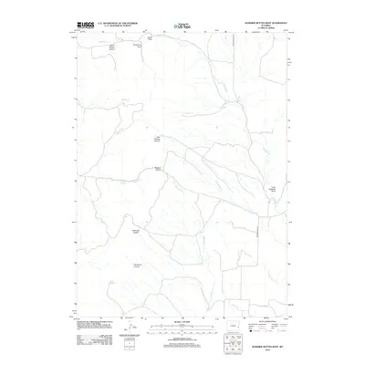
2012 Map of Rawhide Buttes West
USGS Topo · Published 2012About this map
Rawhide Cr and its numerous tributaries define the drainage patterns of this Goshen County landscape. The area is characterized by a complex network of named erosional features including School Section Canyon, Foxworthy Draw, and Lamb Draw in the north, giving way to Little Wildcat Canyon and the larger Muskrat Canyon near the center of the sheet. Water sources appear as isolated but vital points in this arid environment, represented by Muskrat Spring and Twin Springs. The land use is evidenced by a sparse road network, primarily Rawhide Butte Rd and Silver Springs Rd, which provide access through the dissected terrain toward Little Rawhide Butte. This 2012 survey illustrates how modern infrastructure follows the natural corridors created by waterways like Muskrat Cr and Negro Baby Cr.
Find a feature on this map
19 named features on this map. Tap any name to fly to it.
Don’t see what you’re looking for? This feature index may not catch every label — zoom into the map to look around manually.
Map Details
Editions of this 2012 Rawhide Buttes West Map
This is the sole edition of this map. No revisions or reprints were ever made.
Other maps of this area

1896 · Patrick
USGS Topo · 1:125,000

1896 · Hartville
USGS Topo · 1:125,000

1901 · Hartville
USGS Topo · 1:125,000

1950 · Hell Gap
USGS Topo · 1:24,000
1951 · Hell Gap
USGS Topo · 1:24,000

1951 · Moore Spring
USGS Topo · 1:24,000

1954 · Torrington
USGS Topo · 1:250,000

1958 · Torrington
USGS Topo · 1:250,000

1974 · Lone Tree Hill
USGS Topo · 1:24,000
1974 · Jay Em NW
USGS Topo · 1:24,000