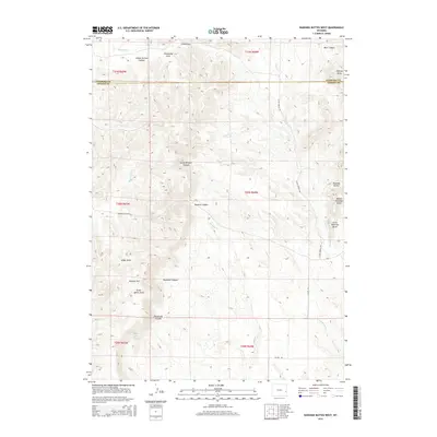
2015 Map of Rawhide Buttes West
USGS Topo · Published 2015About this map
The Rawhide Buttes dominate this high-plains landscape along the border of Niobrara and Goshen counties, showcasing a terrain defined by deep erosional draws and canyons. This section of Wyoming is marked by significant topographical relief, from the Wildcat Hills in the southwest to the distinct peaks of Middle Rawhide Butte and Little Rawhide Butte in the east. Water sources, vital in this arid environment, are recorded at Muskrat Spring and Twin Springs, while drainage patterns are carved into the earth as Deadman Canyon, Muskrat Canyon, and School Section Canyon. The presence of Grant Agnew Draw and Hargraves Canyon points to the legacy of early ranching families who navigated this complex geography. Transportation is limited to rugged corridors like Rawhide Butte Rd and Silver Springs Rd, reflecting the remote and rural character of the region.
Find a feature on this map
33 named features on this map. Tap any name to fly to it.
Don’t see what you’re looking for? This feature index may not catch every label — zoom into the map to look around manually.
Map Details
Editions of this 2015 Rawhide Buttes West Map
This is the sole edition of this map. No revisions or reprints were ever made.
Other maps of this area

1896 · Patrick
USGS Topo · 1:125,000

1896 · Hartville
USGS Topo · 1:125,000

1901 · Hartville
USGS Topo · 1:125,000

1950 · Hell Gap
USGS Topo · 1:24,000
1951 · Hell Gap
USGS Topo · 1:24,000

1951 · Moore Spring
USGS Topo · 1:24,000

1954 · Torrington
USGS Topo · 1:250,000

1958 · Torrington
USGS Topo · 1:250,000

1974 · Lone Tree Hill
USGS Topo · 1:24,000
1974 · Jay Em NW
USGS Topo · 1:24,000