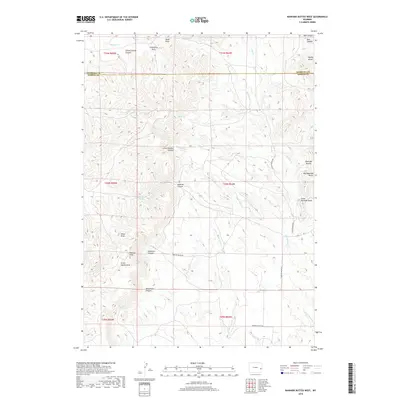
2018 Map of Rawhide Buttes West
USGS Topo · Published 2018About this map
The Wildcat Hills and the prominent rising peaks of the Rawhide Buttes dominate this high plains landscape along the boundary of Niobrara and Goshen counties. This 2018 survey reveals a terrain defined by dramatic vertical relief, where water sources like Muskrat Spring and Twin Springs were vital for life in an otherwise arid environment. The map details a complex system of drainage and erosion, including Deadman Canyon, Muskrat Canyon, and Little Wildcat Canyon. Transportation across this topography is limited to rural routes like Silver Springs Rd and Rawhide Butte Rd, which navigate the gaps between formations such as Mid Rawhide Butte and Flattop Butte. The nomenclature reflects a heritage of early western navigation, tracing the draws and canyons that carve through the high plateaus of eastern Wyoming.
Find a feature on this map
34 named features on this map. Tap any name to fly to it.
Don’t see what you’re looking for? This feature index may not catch every label — zoom into the map to look around manually.
Map Details
Editions of this 2018 Rawhide Buttes West Map
This is the sole edition of this map. No revisions or reprints were ever made.
Other maps of this area

1896 · Patrick
USGS Topo · 1:125,000

1896 · Hartville
USGS Topo · 1:125,000

1901 · Hartville
USGS Topo · 1:125,000

1950 · Hell Gap
USGS Topo · 1:24,000
1951 · Hell Gap
USGS Topo · 1:24,000

1951 · Moore Spring
USGS Topo · 1:24,000

1954 · Torrington
USGS Topo · 1:250,000

1958 · Torrington
USGS Topo · 1:250,000

1974 · Lone Tree Hill
USGS Topo · 1:24,000
1974 · Jay Em NW
USGS Topo · 1:24,000