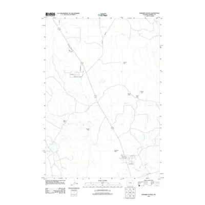
2012 Map of Rawhide School
USGS Topo · Published 2012About this map
Rawhide Butte and Franey Rock dominate this Campbell County landscape, illustrating the distinctive topography of the Powder River Basin at the start of the 2010s. The area is defined by an intricate network of drainage channels including Rawhide Cr, Little Rawhide Cr, and Hay Cr, alongside numerous named coulees such as Rough Draw and Box Draw. This transition from open range to modern infrastructure is marked by residential developments near Island Dr and Pineview Dr, while older transportation routes like Old Hwy 59 remain visible on the land. The presence of Grant Spring in the northern reach suggests the vital importance of water sources in this high plains environment. This survey captures a moment when traditional landmarks and early-century roads met the expanding footprint of contemporary rural Wyoming living.
Find a feature on this map
28 named features on this map. Tap any name to fly to it.
Don’t see what you’re looking for? This feature index may not catch every label — zoom into the map to look around manually.
Map Details
Editions of this 2012 Rawhide School Map
This is the sole edition of this map. No revisions or reprints were ever made.
Other maps of this area

1954 · Gillette
USGS Topo · 1:250,000

1955 · Gillette
USGS Topo · 1:250,000

1958 · Gillette
USGS Topo · 1:250,000

1962 · Gillette
USGS Topo · 1:250,000

1971 · Gillette East
USGS Topo · 1:24,000

1971 · Wildcat
USGS Topo · 1:24,000

1971 · Oriva NW
USGS Topo · 1:24,000

1971 · Oriva
USGS Topo · 1:24,000
1971 · Calf Creek
USGS Topo · 1:24,000
1971 · Gillette West
USGS Topo · 1:24,000