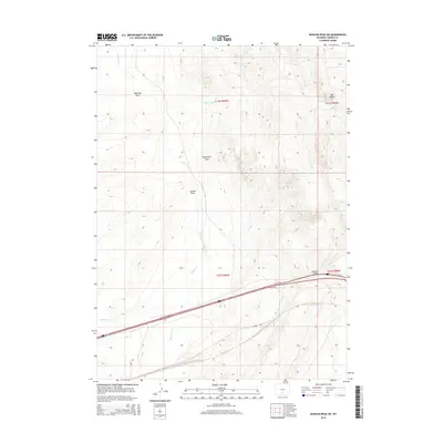
2015 Map of Rawlins Peak SW
USGS Topo · Published 2015About this map
Separation Cr and Fillmore Cr cut through the high desert terrain of Carbon County, marking a landscape defined by seasonal water and wide drainage basins. This 2015 survey shows a region largely characterized by its natural features, where the arid Separation Flats provide a level expanse between the rising elevations of Big Rocks and the various draws like Mahoney Draw. Infrastructure in this part of Wyoming is sparse, with primary access provided by Knobs Rd and Daley Rd. A notable point of navigation is the Eightmile Bridge, which serves as a fixed landmark over the Interstate corridor. The map details the Township and Range grid across sections like t21n r89w, revealing the systematic division of these western lands. The presence of Indian Spring highlights the critical importance of reliable water sources in this dry Wyoming environment.
Find a feature on this map
12 named features on this map. Tap any name to fly to it.
Don’t see what you’re looking for? This feature index may not catch every label — zoom into the map to look around manually.
Map Details
Editions of this 2015 Rawlins Peak SW Map
This is the sole edition of this map. No revisions or reprints were ever made.
Other maps of this area

1954 · Rawlins
USGS Topo · 1:250,000

1956 · Rawlins Peak
USGS Topo · 1:62,500

1956 · Bridger Pass
USGS Topo · 1:62,500

1958 · Rawlins
USGS Topo · 1:250,000

1960 · Buck Draw
USGS Topo · 1:24,000

1962 · Rawlins
USGS Topo · 1:250,000

1966 · Riner
USGS Topo · 1:24,000
1966 · Antelope Spring
USGS Topo · 1:24,000

1967 · Rawlins
USGS Topo · 1:250,000
1983 · Coal Mine Ridge
USGS Topo · 1:24,000