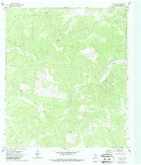
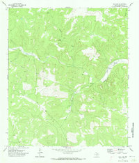
1971 Map of Ray Lake
USGS Topo · Published 1987About this map
The South Llano River carves through the Edwards County landscape, defining the character of this ranchland in the early 1970s. The water-scarce terrain is marked by intermittent features such as Cloudt Draw and McKenzie Draw, which highlight the importance of localized water sources like the Cloudt Waterhole and the small reservoir of Ray Lake. Human activity in this rural stretch is largely defined by ranching infrastructure and mineral exploration, evidenced by the Baker Ranch Landing Strip and various resource extraction points. Deep-seated industrial markers including a Gas Well, a Drill Hole, and a Gravel Pit appear alongside several Pipeline segments, indicating the ongoing development of the region's energy and material resources beneath the surface.
Find a feature on this map
11 named features on this map. Tap any name to fly to it.
Don’t see what you’re looking for? This feature index may not catch every label — zoom into the map to look around manually.
Map Details
Editions of this 1971 Ray Lake Map
2 editions found
Other maps of this area

1893 · Rock Springs
USGS Topo · 1:125,000

1954 · Sonora
USGS Topo · 1:250,000

1958 · Sonora
USGS Topo · 1:250,000

1962 · Stewart Ranch
USGS Topo · 1:24,000
1962 · Bundy Ranch
USGS Topo · 1:24,000

1963 · Harrison Ranch
USGS Topo · 1:24,000

1970 · Ray Lake NW
USGS Topo · 1:24,000
1971 · Ray Lake SE
USGS Topo · 1:24,000
1971 · Rocksprings
USGS Topo · 1:24,000
1971 · Ray Lake
USGS Topo · 1:24,000