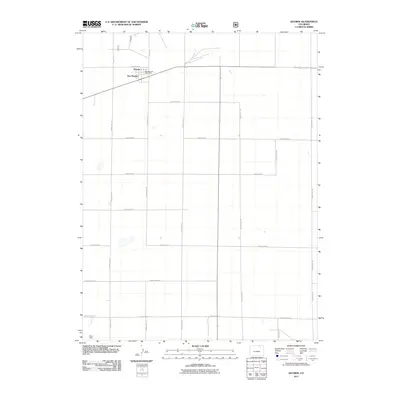
2011 Map of Raymer
USGS Topo · Published 2011About this map
Raymer and New Raymer anchor this high-plains landscape in Weld County, where the grid of agricultural roads defines the terrain's character. The presence of the New Raymer Post Office indicates the enduring center of the local community, while Wirth Field stands out as a localized landmark to the southwest. This 2011 survey illustrates a highly structured rural environment, dominated by long-stretching county routes such as County Rd 86 and County Rd 127. The sparse distribution of named features underscores the transition from established settlements to the open grazing or dry-land farming territory typical of the region, providing a clear record of modern property and transport boundaries.
Find a feature on this map
24 named features on this map. Tap any name to fly to it.
Don’t see what you’re looking for? This feature index may not catch every label — zoom into the map to look around manually.
Map Details
Editions of this 2011 Raymer Map
This is the sole edition of this map. No revisions or reprints were ever made.
Other maps of this area

1951 · Dead Horse Springs
USGS Topo · 1:24,000

1951 · Peace Valley School
USGS Topo · 1:24,000

1951 · Judson Hills
USGS Topo · 1:24,000

1954 · Sterling
USGS Topo · 1:250,000

1958 · Sterling
USGS Topo · 1:250,000
1977 · Raymer NW
USGS Topo · 1:24,000

1977 · Stoneham
USGS Topo · 1:24,000

1977 · Raymer NE
USGS Topo · 1:24,000
1978 · Buckingham
USGS Topo · 1:24,000

1978 · Stoneham NW
USGS Topo · 1:24,000